Land Survey Cost: What You’ll Actually Pay, and Why Nobody Can Quote You a Number

Land survey cost sits somewhere between $400 and $12,000, and if that range feels useless to you, good. It should. Every cost guide on the internet will hand you a national average and send you on your way, and on raw land that average is describing somebody else’s property.
I went through about a dozen of them while researching this. They don’t just disagree. They contradict each other. One of the big home services sites quotes $800 to $5,500 per acre with a national average of $2,300. Another says $375 to $745 with an average of $525. A third puts it at $200 to $1,200. And one manages to say surveys run $377 to $770 in one paragraph and then $1,500 to $3,500 per acre a few paragraphs later, in the same article, without noticing.
They’re not being sloppy, exactly. They’re describing different jobs and not telling you which one. So let me explain the thing that actually determines your bill, because once you get it, every one of those numbers makes sense.
On a rural build the survey is usually the cheapest line item and it decides the most. Every setback and separation distance gets measured from those pins, and everything on the property has to clear everything else. I went through how the pieces fight each other in the off grid cabin guide, including why siting the septic, the well and the array one at a time is how people end up moving things twice.
Why the quotes swing so wildly
Surveyors price small lots and big parcels in completely different ways.
Under about half an acre, most of them charge a flat fee. Doesn’t matter much whether your lot is 0.3 acres or 0.5, because the work is roughly the same. Drive out, research the deed, find the corners, shoot the lines, draw it up. That’s where the $400 to $900 numbers come from.
Once you’re into real acreage, they price per acre. And here’s the part nobody explains clearly: the per acre rate drops as the parcel gets bigger. A single acre might run $500 to $1,000. By the time you’re at 80 acres you’re looking at roughly $75 an acre, and around $65 an acre at 100. Between 50 and 100 acres the going rate lands somewhere around $70 to $140 an acre.
Do the math on that and the shape becomes obvious. Twenty acres does not cost twenty times what one acre costs. The perimeter is what the surveyor walks, and perimeter grows a whole lot slower than area does. Doubling your acreage doesn’t double your bill.
Which means the “national average” everyone quotes is a suburban half acre number, and the “per acre” figure is a small parcel rate. If you’re buying forty acres of timber, neither one is talking about you.
What kind of survey you actually need
This matters more than acreage for a lot of people, because ordering the wrong type is how you pay twice.
| Survey type | What it’s for | Typical cost | How long |
|---|---|---|---|
| Boundary | Marking your actual property lines | $400 to $900 | 1 to 2 days on a small lot |
| Mortgage or location | Lender wants it before closing | $400 to $1,000 | Usually a few days |
| Topographic | Elevation and features for building | $500 to $1,200 | 2 to 5 days |
| ALTA/NSPS | Commercial standard, very detailed | $2,500 to $10,000 | Weeks |
For most people buying rural land, a boundary survey is the one. It tells you where your lines are and puts physical markers in the ground at your corners.
You’d add a topographic survey if you’re actually building and need to know how the ground falls, which matters for drainage, for where a foundation sits, and for whether your driveway is going to wash out every spring. ALTA is commercial territory and you almost certainly don’t need it.
The mortgage or location survey is the one to watch. If you’re financing, your lender may require it, and it is not the same thing as a boundary survey. It confirms the structures sit inside the lines and flags easements. It won’t necessarily mark your corners. Plenty of people pay for one, assume they’ve been surveyed, and then find out later they still don’t know where their line is.
What pushes the number up
Four things, and three of them are aimed squarely at anyone buying the kind of land I write about.
Terrain. Wooded, hilly or overgrown ground adds 20 to 50 percent, because somebody has to physically clear sight lines and walk your corners through it. This one stings. The premium is for trees and slope, which is exactly what cheap remote acreage is made of. The land you want is the expensive land to survey.
Records. If the deeds are missing, vague, or fighting each other, add $200 to $1,000 of courthouse and title research before anyone sets foot on the property. Old rural deeds are frequently a mess. Metes and bounds descriptions referencing a stone pile and a dead oak tree are a real thing, and somebody has to reconcile that with reality.
Region. High cost metros run 20 to 40 percent above the national numbers. Rural South and Midwest run below. Your zip code moves this a lot.
Access. If the surveyor has to hike in or can’t get equipment near the corners, that’s time, and time is the bill.
How long it actually takes
Nobody leads with this and it bites people mid closing.
A small accessible lot with clean records is one to two days of field work. Large acreage, or anywhere the boundary records are unclear or disputed, can run several weeks to a month. If you’re under contract with a closing date, ask about the calendar before you ask about the price.
What you’re actually buying
This surprised me a bit when I dug in, because it’s more physical than I expected.
A boundary survey isn’t just a drawing. The surveyor hunts down whatever corner monuments already exist, iron pipes, iron rods, section corners, old fence lines, then compares all of that against your recorded deed to work out where the boundary legally sits. Where corners are missing, they set new iron rods. Then you get a map showing the boundary, the monuments they set, any encroachments they found, the legal description, and their certification with their seal and license number.
One detail on that map is worth understanding. The legend distinguishes between pins that were found and pins that were set. Found means the corner was already established and the surveyor located it. Set means it wasn’t there and they placed a new one based on the records. A boundary reconstructed mostly from set pins rests on more interpretation than one where the original monuments were all still in the ground. Ask which yours is.
Before you pay anybody, go look for your pins
Genuinely, do this first. It’s free and it sometimes changes the whole conversation.
Most residential corner markers are iron rebar, roughly 18 to 24 inches long, often capped with plastic or brass stamped with the surveyor’s license number. That number is what proves the marker is legit rather than some random bit of scrap. Older properties might have iron pipes or a brass disc set in concrete.
Pull your plat if you have one, grab a metal detector, and spend an afternoon walking your corners. A decent number of people discover their property was surveyed twenty years ago and the pins are sitting right there under four inches of leaf litter.
If your land was ever federal public domain, which covers most of the country west of Ohio, there’s a second place worth checking. The BLM’s General Land Office records hold over five million federal land title records for free, plus original survey plats and field notes going back to 1810. Those field notes are the surveyor’s handwritten record of bearing trees, witness corners and monuments set, which is about as close to primary evidence as you get on an old boundary. It won’t help you in the original colonies, Texas or Hawaii, but everywhere else it’s free and nobody uses it.
Two rules. Never move a pin you find, because it’s a legal monument and moving it causes problems far bigger than whatever you were trying to solve. And if you find some but not all of them, tell the surveyor when you call, because existing monuments cut down the work.
The part that matters if you’re building off-grid
Every other page on this topic is written for somebody in a subdivision who wants to put up a fence. Fine. But if you just bought raw land and you’re planning to live on it, the survey is doing a different job, and I don’t see anyone saying this.
Your survey isn’t about the boundary. It’s about whether you can build.
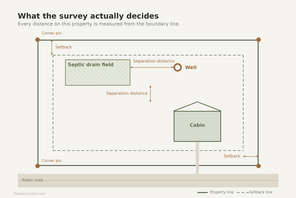
Original diagram. Reuse it with a link to theopencurrent.com.
Setbacks measure from property lines. So until you know where your corners actually are, you don’t know where your septic field can legally go, you don’t know where your well can go relative to that field, and you don’t know where the cabin can sit. Those three things have separation distances between them and from your lines, and all of it is measured from a boundary you’re currently guessing at.
I’ve seen people do a perc test before they had a survey, get a great result, and then find out the only spot that percs sits inside a setback. That’s a wasted perc test and a redesigned site plan. Order matters here. Survey, then perc, then design, then dig. The septic system cost guide walks through what happens after the perc comes back.
Then there’s access. A dirt track that everyone has always used is not legal access unless a document or a court says so. A parcel with no enforceable right to reach it from a public road is landlocked, and that can make it nearly worthless. Your survey shows whether any existing road actually crosses a neighbour’s land, and where an easement would need to run if you have to negotiate one. If a seller can’t show you corners and can’t show you recorded access, that’s not a bargain, that’s a warning.
And easements you can’t see by walking it. Oil, gas and pipeline corridors, utility rights of way, floodplain lines that constrain where you’re allowed to build. These don’t show up on a nice afternoon walk. They show up on a survey and in the title work.
If you’re pricing out a whole build rather than just this one line item, the off-grid cost calculator puts the water, wastewater, heating and power numbers together so you can see what the total actually looks like.
Fences, and why they lie
Quick one, because it comes up constantly.
Rural owners assume the fence line or the tree line is the property line. It frequently isn’t. Old fences get built by whoever was there, in roughly the right place, with a post driven where the ground was soft. Being off by several feet is normal, and being off by a lot more than that is not rare.
Here’s the part with teeth. If a fence line, tree line or driveway has been treated by both sides as the boundary for long enough, in a lot of states ten years, that line can become the legal boundary even though it differs from the surveyed one. Which cuts both ways. You can quietly gain ground, and you can quietly lose it.
So if you’re putting up a fence, survey first and build to the line. And if you find somebody else’s fence sitting on your land, say something in writing now, not in eight years when it’s become theirs by default.
When you genuinely don’t need one
House rule around here is that I tell you when the obvious purchase isn’t the right call, so here it is.
A survey is generally good for five to ten years depending on your state’s rules. If the seller has a recent recorded survey, you may not need a new one at all. Ask for it early in the process, because it’s free to ask and it might save you two grand.
Your county GIS site has parcel maps for free, and for a rough sense of shape and acreage that’s often enough. It is not legally binding and the data can be well out of date, so don’t build a fence off it. But for “is this parcel roughly the shape the listing says,” it’s fine.
If you’re buying a platted lot in a recorded subdivision, the boundaries were established when the plat was filed and the corners were probably monumented then. Different situation from forty acres carved out of a farm in 1958.
What you can’t do is survey it yourself. You can locate your own pins all day, but you cannot produce a legally valid survey without a license. The options are pay a surveyor or don’t have a survey. There’s no DIY middle.
For what it’s worth, the usual framing on land due diligence is that all your specialists together, surveyor, soil, title, attorney, tend to come in under 1 to 2 percent of the purchase price. On a $40,000 parcel that’s a pretty easy argument to win.
Questions to ask before you sign anything
I’d ask all of these on the phone. A good surveyor answers them without getting twitchy.
- Which type of survey is this, and what do I physically get at the end? A stamped plat? A recorded survey? Just marked corners?
- Will you set and mark every corner, and with what? Capped rebar, pipe, concrete monument?
- Are you recording it with the county, or is that on me?
- Is records research included, or does that get billed separately if the deeds don’t line up?
- Is line clearing included? Who pays if my ground needs it?
- Flat fee or hourly? If hourly, what’s the thing most likely to blow past the estimate?
- Realistically, how long from signing to plat in my hand?
If someone quotes you a single lump number and won’t break it down, that’s the same tell it is in every other trade. Ask for it itemised in writing.
On finding somebody in the first place, your state surveying society is a better starting point than a lead matching site. Every state has one, they’re listed through the national body, and their members are licensed in the state you’re actually buying in.
What to do the day after, which nobody tells you
This is my favourite bit of advice in this whole article and I haven’t seen it anywhere else.
Once the survey is done, go walk your corners yourself. Photograph each pin. Drop a GPS pin on your phone at every one of them. Write down the surveyor’s name and the license number stamped on the caps. Keep all of it with your deed.
Monuments disappear. They get buried under leaf litter, clipped by a brush hog, bulldozed during a driveway build, frost heaved, and occasionally just taken. Ten years from now, when a neighbour questions your line or you’re selling, a corner you can walk straight back to is worth a great deal more than a piece of paper in a drawer.
Also make sure the plat actually gets recorded with the county. A survey sitting in your filing cabinet is worth less than one in the public record.
Frequently asked questions
How much does a land survey cost per acre? For a single acre, roughly $500 to $1,000. The rate drops as the parcel grows, landing around $70 to $140 an acre in the 50 to 100 acre range. Don’t multiply a one acre price by your acreage, because that’s not how the pricing works.
How long is a land survey good for? Generally five to ten years depending on your state. The boundaries themselves don’t move, but records change, monuments go missing, and lenders and title companies often want something recent.
Can I do my own land survey? You can find your own pins with a plat and a metal detector, which is genuinely useful. You cannot produce a legally valid survey without a surveyor’s license, and only a certified survey holds up in a dispute.
Who pays for the survey when buying land? It’s negotiable and varies by state and contract. If a lender requires a mortgage or location survey for closing, that often falls to the buyer. A boundary survey you’re ordering for your own peace of mind is usually on you.
Do I need a survey to buy raw land? You’re not legally required to have one in most cases. But on unplatted rural land with no visible corners and no recent survey, skipping it means you’re buying a parcel whose actual shape and size you’re taking on faith.
What’s the difference between a plat and a survey? The survey is the work, the fieldwork and research that determines where the boundary is. The plat is the map that comes out of it. The plat is the thing you file with the county and hand to your contractor.
Why is my survey quote so much higher than my neighbour’s? Usually acreage, terrain and records. Your neighbour with a cleared five acre field and a survey from 2019 is a different job from your forty wooded acres with a deed written in 1958. Both quotes can be fair.
Where to go from here
If you’re buying, ask the seller for an existing survey before you do anything else. It’s one email and it sometimes saves you the whole expense.
If you’re building, get the survey before the perc test, not after. The order saves you money and I’ve watched people learn that the hard way.
And whatever you spend, go find your corners afterwards and record where they are. The reason you’re reading a page about survey costs is probably that nobody did that last time.
Next:
- Perc Test Guide for the test that decides what you can build
- Septic System Cost for the number that follows it
- Off-Grid Cost Calculator for pricing the whole build, not just the line items